35+clients
Government, business, infrastructure since 2018
Data Annotation
GIS-native labeling for road assets, signs, lane markings, and infrastructure — with QA trails reviewers can trust.
Custom web maps, imagery review, field systems, automation, annotation, and decision reports for teams that need spatial data to become a working product.
Government, business, infrastructure since 2018
GIS-native labeling for road assets, signs, lane markings, and infrastructure — with QA trails reviewers can trust.
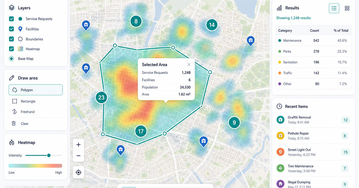
Interactive dashboards and routing tools built with Mapbox, Leaflet, and Google Maps for the workflows your team actually runs.
Satellite, drone, and aerial imagery for monitoring, change detection, and asset extraction at sub-meter precision.
ETL pipelines that replace manual geoprocessing — joins, buffers, routing, and imagery packaged into controlled workflows.
Address-to-report packages for site selection, environmental risk, and trade-area analysis.
GIS consulting, custom web maps, spatial automation, and location intelligence workflows.
Maps, reports, dashboards, and review queues built around the decision your users need to make.
Data intake, map state, evidence panels, export paths, and documentation that survive beyond the first demo.
Start from the closest live demo, then adapt it to your data, users, and delivery path.
Bring the closest real workflow. We map what you send, what your team reviews, what evidence stays visible, and what you receive at handoff.
Addresses, routes, parcels, imagery, asset layers, or the manual workflow you want to replace.
A focused browser map with layers, filters, popups, evidence panels, and state your users need.
Plain-language notes, source context, confidence, limits, and QA boundaries stay visible with the output.
A hosted map, report, dashboard, field form, CSV, GeoJSON, or scoped build path.
Start with one credible proof artifact before larger spend.
Stack choices depend on users, data, performance, budget, and maintenance path.
Addresses, routes, parcels, imagery, asset layers, field forms, spreadsheets, or GIS workflows.
Source notes, limitation notes, evidence panels, and export checks.
Hosted map, report, dashboard, field form, CSV, GeoJSON, or scoped build path.
No vague discovery phase. You bring four or five things, we return a specific plan you can evaluate.
No open-ended retainers. No "discovery phases" that bill for months without producing anything you can evaluate.
You send a data sample and a target outcome. We return a written scope, fixed price, and pilot plan within 48 hours.
A clickable web map or analysis run on a slice of your data — fixed fee, evaluable in under 2 weeks.
Full build with documentation, runbooks, and source code transfer. Deployed on your infrastructure or ours.
Recorded walkthroughs, training session with your team, and 30-day hardening period where we stay on call.
These open the real, interactive demos on our main site — not screenshots, not videos. Click around before you decide to talk to us.
We start with the data. You send a representative sample, we look at it live on a 30-minute call, and we surface the highest-leverage build candidate based on what we actually see — not what we assume from a brief.
A working web map or analysis pipeline, documented runbooks, source code transfer, a 30-day post-launch support window, and either a quarterly maintenance retainer or full self-serve handoff — your call.
Yes. About 40% of our work is government or grant-funded — federal, state, and municipal. We are familiar with NDA, FAR, and federal procurement workflows.
Yes. Every engagement starts with a fixed-fee pilot — a single demo map, an automation prototype, or an analysis run on your data. Pilots range $2.5k-$8k and produce a deliverable you evaluate before any larger commitment.
A short path for teams that already know they need a map, imagery review, report workflow, or geospatial autom…
Start with a working map example, then talk through the data, decisions, and deliverable your team needs. We w…
Choose the closest workflow, send the rough context, and we will turn it into a scoped path for a map, report,…
Dispatch optimization, container tracking, and demand prediction built for roll-off dumpster companies — runni…
Free, 30 minutes, no slide deck. We will look at your data live and tell you what is buildable, what is not, and what a realistic timeline looks like.
Bring a location problem